Frontier: The Dominican-Haitian Border Region, 2015-Present
| Back to Images |
"A good place to understand the present, and to ask questions about the future, is on the ground, traveling as slowly as possible."
– Robert D. Kaplan, The Revenge Of Geography
Project Narrative
Working Title: “Frontier: A Visual Documentation of the Haitian-Dominican Border Region”
Content:
Part I: Research, Overview and Proposal
1. Contextual Overview
2. Project Proposal
3. Project Goals
4. Immediate Objectives
5. Projected Deliverables
Part II: Initial Report on Research
1. Summary Statement of Proposed Research
2. Methodology
3. Accomplished Objectives
4. Changes and Updates to Original Project
5. Portfolio of Images
Part I: Research, Overview and Proposal
Contextual Overview
The island of Hispaniola (as named by Christopher Columbus) or Quisqueya (as native Tainos used to called it) is the only island in the world that is shared by two independent countries, neither of which are territories of countries elsewhere. This relatively small island is shared by two nations, two peoples with markedly different cultures where language, ethnicity, and customs have usually separated them, and the only unifying element has been the land. This situation has historically created tensions, which at times have turned into terrible conflicts, like the Haitian invasion of Dominican territory in 1822, or the massacre of Haitians in 1937 during the Trujillo dictatorship. During the past couple of decades leading up to today, Haiti’s deteriorating socio-economic situation, worsening by the effects of deforestation, natural phenomenon like hurricanes and the devastating earthquake of 2010, epidemics like AIDS in the 1980s and 90s, the more recent cholera outbreaks, as well as the current political instability and rampant gang violence, have reinforced a continuing exodus to the eastern Dominican side. At the same time, an increasing dependence on low-cost Haitian labor has led not only to corruption and disregard of immigration laws, but to elevated social tensions within the Dominican population, particularly in areas with a high concentration of Haitian migrants and among those with more conservative nationalist views. While Haiti has fallen among one of the poorest countries in the world, it is important to keep in mind that the Dominican Republic is still an underdeveloped country, (even though it has enjoyed a slow but steady progress). The Inter-American Commission on Human Rights (IACHR) estimated 500,000 – 700,000 Haitians were living in Dominican territory in 1999; Human Right Watch (HRW) quoted the head of the Dominican army in 2001 as placing the number around one million, and more recently other sources and media reports have guessed the number to be anywhere between 1 and 2 millions. While the exact number might be difficult to calculate, Haitians seem to have reached more than 10% of the population in Dominican Republic, the vast majority undocumented, inevitably causing strain in a nation incapable of absorbing or supporting such migration. On September 23 of 2013, the Constitutional Court of the Dominican Republic ruled to reinforce existing immigration laws in place since 1929, exposing undocumented Haitians and their children (even if born on Dominican soil) to possible deportation. The uncontrolled migration and the severity of the court resolution have raised new tensions on both sides of the island.
Project Proposal
The proposed project is a photographic documentation of the frontier region between the Dominican Republic and Haiti, supported simultaneously by first person accounts, official documentation, and other forms of data.
The border for most people on both countries remains a mystified region, little understood, the result mostly of irresponsible misconceptions and distrust for the “other”. My intention is to create a more accurate portrait of the place where these two nations first come into contact by visually documenting the landscape, living conditions and infrastructure, as well as exploring the intertwined relationships––social, economic, and personal––among inhabitants of the area.
The Haitian-Dominican border is about 380 km stretching north to south, (see map below). It has several land-crossing points most importantly in the towns of Dajabon (DR) and Ouanaminthe (Haiti), Belladere (Haiti) and Elias-Piña (DR), Jimani (DR) and Malpasse (Haiti), and Pedernales (DR) and Anse-à-Pitres (Haiti), as well as other enclaves and less inhabited areas on both sides. I am hoping to create a more humane and clearer picture by documenting the different levels of interactions and dependence among these areas. Certain interactions might seem obvious, such as open market days that allow Haitians and Dominicans to freely cross the border to adjacent towns, the traffic of goods and people (legal and otherwise), and facilities like schools and hospitals that serve the inhabitants of not only one side but also the other. Other daily realities might be more elusive, like the intimacy of domestic routine, personal relationships and family ties (many times not defined by nationality but affected by the frontier), the landscape and environmental conditions and their effect on living conditions, respect and enforcement of law (or lack there of), pride, dignity, and the desire for a better life. These areas of contact are of as much relevance if we are to understand the complexity of the region.
The marginalization of the area on one hand, and the paranoid protection of the border on the other, have contributed to keeping alive on both sides a feeling of fear, superstition, conflict, and resentment dating back to colonial times. This project is not proposing a quick solution, but a portrayal of the area with scope and sensitivity that may contribute to a better understanding of the powerful influences the two countries exert on each other.
An extensive visual study of the border region on both sides of the island does not yet exist. Meanwhile, propagandistic and sensationalized accounts pointing fingers at one side or the other abound contributing to instability in the region. Deterioration of the border zone and irresponsible speculation affects not only tensions between the Dominican Republic and Haiti, but it also has repercussions in the larger Caribbean region, such as in policies established by organizations like CARICOM and OAS. It also affects the interests of countries like the United States, France, and Canada who have long histories and some would say “responsibilities” towards the island, as well as large populations of both Haitians and Dominicans among their citizens. Attention to the area is key for the future economic development and stability of both nations. It is hard to think of a more pressing time for the realization of this proposal.
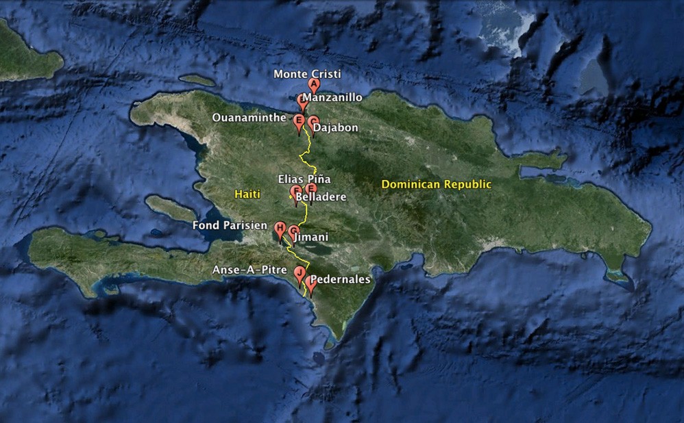
Map provided by Google Earth. Note that location pins have been slightly separated to provide better visual definition. In most cases, the towns are closer to the border.
Project Goals
The goal of the project is to create a body of work about this unique and marginalized geographic area exposing the social and environmental realities, as well as the complex relationship amongst the inhabitants from both sides. The final form of the work is envisioned in several possible ways:
- As a visual (photographic) narrative in book format accompanied by supporting text,
- As an itinerant exhibition installation in spaces of broad public access,
- As a permanent physical and/or online archive.
Other outlets are being considered.
As I embark on this project, I am keeping in mind a broad audience that goes beyond the fine art and photography fields. The subject and approach hope to appeal and find use in the hands of those in the cultural area, government and policy makers, international relations, migration, development, social justice, environment and sustainability, health, and several other areas of study and education. While the target audience seems broad, the subject does indeed address all these fields, and the approach aims at creating compelling images as well as valuable data.
Immediate Objectives
The first stage of research will aim at building a solid foundation for this project, which in turn will be used to obtain support for further research, completion, and dissemination of the work. The following immediate objectives will be undertaken during this period:
- Visual photographic survey of the region, concentrating at first on the specific towns mentioned earlier; these are located at each side of the four main border-crossing points along the frontier. I will initially focus on subjects such as infrastructure, landscape, streets and public life, border activity and traffic, portraits of locals, and Dominican-Haitian interactions. These situations will lead to others developing into more complex narratives.
- Identify individuals and build a local support network that could provide particular insight and facilitate research further along: community leaders, local residents, institutional officials (doctors, aid workers, teachers, priests, police, others), community centers, and other local organizations.
- Activate and strengthen exciting personal network in Haiti and Dominican Republic. This network consist of current and former government officials in both countries, academics in PUCMM University in DR, cultural institutions, aid organizations, acquaintances that live close to the border, and friends and relatives in other areas in both countries.
- Gathering of supporting and alternative data from sources such as interviews and first person accounts, public records, survey and institutional studies, and local media. Other alternative sources, while less factual, can shed light into the local psyche such as fictional literary works, folk stories, local common expressions, and more.
- Develop further the framework of the project by: identifying specific areas of deeper investigation, evaluating methodology and technical process (and readjusting if needed), and refining the conceptual basis and written language of the project.
Projected Deliverables
At the completion of the initial research period, the following items are expected to be completed:
- Full report containing the details and outcomes of the research activities during this period.
- Portfolio of exhibition prints of images carefully selected from the resulting research project.
- Refined and expanded project statement and proposal in accord with the requirements of external grants agencies being targeted.
Part II: Initial Report on Research
Summary Statement of Proposed Research
The initial proposal described the project as a photographic documentation of the frontier region between the Dominican Republic and Haiti, supported simultaneously by first person accounts, official documentation, and other forms of data.
The premise for the project remain valid and in most aspects reaffirmed. Instead of restating the contextual overview and proposal, I will point out the changes and adjustments that will be made to the proposal and final project statement to be used in further funding applications:
- Immigration. The Project aims at creating a visual portrait of the reality lived in the Dominican-Haitian border region. To do this, the scope of the proposal is broad, examining different aspects such as landscape and environment, social and economic issues, relations and interactions across the border, and public and domestic life among other things. The issue of illegal immigration of Haitians to the Dominican Republic was up to now just another important topic to be addressed. However, special attention will be placed here given recent local and international events. This issue became particularly contested in the island at the beginning of this summer as the deadline for foreigners to regularize their status in the Dominican Republic approached on June 17th, and the possibility of deportations was to become real soon after. By the end of the summer the following events had taken place: first, the Dominican Republic had granted legal status to over a quarter million (288,000) foreigners (most of them Haitians); second, the international community, including the OAS and other countries outside of this organization like the UK, recognized the Dominican Republic’s rights to set and enforced its own immigration laws; and third, Haiti had to faced the possibility of a large number of people being repatriated. More recent events in Europe are echoing some of these massive migratory problems.
- Demographics Along the Border. As stated in the initial statement and proposal, larger populations are concentrated in mirroring towns with official border crossing and customs check points, with smaller enclaves and desolated areas in between. This is in actuality the case in the Dominican side. However, the Haitian side seems to have a larger concentration of people all along the border pressing right up to the frontier, with very large populations in the main towns in comparison to the Dominican counterparts. This seems to be the result of increased interdependence, commerce, and availability of resources. Dominicans, specially young adults, tend to look east towards larger cities like Santiago and Santo Domingo, or even abroad, because of the lack of employment in their hometowns, not enough higher education institutions, and poor prospective for their future. While there is an apparent effort towards industrial and housing development, it hasn’t been enough to reverse this trend in most places. Haitians similarly, seem to look eastwards closer to the Dominican Republic where commercial exchange and work are more available than other regions of their country.
- Border Security. Protection of the border is almost entirely the responsibility of the Dominican army, specifically the CESFRONT, a special unit of the military assigned to the border. A minimum of Haitian police and migratory officers are found in the custom offices of the four main Haitian towns along the border, (see map). The town on Anse-A-Pitres at the southern end of the border, with a population of 30,000, reportedly has two police officers. Right next to Anse-A-Pitres on the Dominican side, the town of Pedernales, with a population of 12,000, has both a military base and a police department, with several military checkpoints along the roads in the region. However, the frontier remains an extremely porous line. Except for the military presence in the main Dominican towns along the border, there are vast unguarded areas, with small military posts several miles from each other sometimes with one or two soldiers tending to it. Border security is an unresolved problem, which inevitably gives way to contraband (in which people from both sides are involved), land-grab and the cutting of trees to make charcoal (typically done by Haitians coming into Dominican territory), and continuing illegal migration.
- Regional and Bilateral Relations. Relations between Haitians and Dominican along the border region are surprisingly peaceful and cordial. It is common to find Haitians living and working on Dominican towns along the border, and it is normal for Dominicans to interact with them on a daily basis. It is less common however to find Dominicans living on the Haitian side. Regularly, people from both sides cross the border for business purposes. During open market days, typically Mondays and Fridays, the border gates are open to allow for a duty free market. The market itself is usually set up on the Dominican side. The reason for this is not completely clear, and some might find it unfair, but it seems that security and infrastructure might be the main reasons. While the great majority of vendors and buyers come from Haiti, Dominicans from everywhere also come to buy and set up shop. These markets take place all along the border with the largest located by the gates of Dajabon (DR) and Ouanaminthe (Haiti). Haitians also cross to Dominican territory to receive medical care. Primary-care clinics in small towns and countryside along the border, as well as hospitals in the larger towns, receive Haitian patients on a regular basis. Emergencies are tended to daily, while there is one day of the week dedicated to nonemergency visits and check ups only of Haitian patients. Medical centers and resources are limited in towns on the Haitian side of the border, and emergencies and some treatments usually require traveling far to some of the larger Haitian cities. Nowhere along the border did I encounter or was informed of any conflict or problems between the two people. Relationships were seemingly amicable. Institutionalized or community led repression or rejection from either side doesn’t seem to be the norm anywhere along the border region. Having said that, there have been incidents such as crimes, personal disagreements, and even antagonistic reactions towards foreigners -Haitians or Dominicans- by individuals, but these seem part of typical community life rather than a generalized national sentiment against the other. It is important to point out, that as one moves further away from the frontier -on either side- national resentment, antagonism, and/or fear seems to grow. This phenomenon seems to be fueled by lack of education and contact with the other, poverty and competition for resources, and misinformation and political agendas.
Methodology
The following stages describe the process and methodology followed during this initial part of the research project:
1. Establishing contacts in the area. Personal contacts were informed of the project prior arrival to the island. This led to an initial list of potential new contacts and people of interest. During the first week and a half, time was dedicated to following up, meetings, and interviews with existing and new contacts, and planning travel itinerary according to all new information gathered.
2. Identifying geographic areas of initial focus and developing a travel route. The frontier has a length of 380km running north to south. In order to make the most of the research period and resources, it seemed more efficient to concentrate on the four main border-crossing points and the larger towns on each side of these, (see map above). Some areas nearby and in between these main towns were also visited in order to become familiar with the region, and/or because they were particularly pointed out as relevant along the way. Coverage of the area was done in three parts:
- Part 1: The first 3/4 of the frontier region moving north to south.
a) Montecristi. This is one of the largest towns at the northwestern top of the Dominican Republic.
b) Pepillo Salcedo (Manzanillo). This small town borders with Haiti and is where the frontier actually starts.
c) Dajabon (DR) and Ouanaminthe (Haiti). These are mirroring towns at each side of the border and one of the busiest and commercially important crossing points between the two countries.
d) Loma de Cabrera and Capotillo (both on the Dominican side). Close to Capotillo on the Haitian side there is a small town with the same name, Capotille. Unfortunately, there is not a legal crossing point here and while it is informally done, it was not recommended by the military. (A note was made to return and contacts were established that could serve as guides in a near future.)
e) “Carretera Internacional” (The International Road). This road becomes literally the border line with Haiti on one side of the road and Dominican Republic on the other. It is approximately 60km from the Dominican towns of Anacaona to Pedro Santana. In between there are several small Haitian enclaves right by the road such as Ti Louri, La Croix, Nantoro, La Source, El Corte y Calavacié, but on the Dominican side only small military posts are found several miles apart from each other. A military permit is needed to enter and exit the road, and it could take most of the day to transit it because the road conditions are very difficult.
f) Elias Piña (DR) and Belladere (Haiti). These are mirroring towns at each side of the border and one of the main crossing points between the two countries.
g) Jimani (DR) and the towns of Malpasse and Fond-Parisienne (both Haiti). These are mirroring towns at each side of the border and one of the most important crossing points between the two countries. This is the fastest route between the two nations capitals, Port Au Prince and Santo Domingo.
- Part 2: Return to Pepillo Salcedo, better known as Manzanillo.
I thought necessary to return and spend more time in this small town. The Masacre river flows along the northern end of the frontier separating both countries and disemboguing in the Bay of Manzanillo. Manzanillo is the first town adjacent to the border (from north to south), and it is there, at the end of the river, where the first pillar marking the official border line is found. There are 311 concrete pillars delineating the border. The closest Haitian town is several miles away, so the border is not officially open here; however, local authorities loosely allow the casual crossing of known locals. Manzanillo was a “company town” created in the late 1940’s by the Grenada Fruit Company, a subsidiary of the United Fruit Co. The natural and deep bay and the rich soil of the area, as well as the relative closeness to North America, made it an ideal site for the development of the banana industry. After the Grenada Fruit left in the mid 1960s, the population and prosperity of the town declined sharply.
- Part 3: Pedernales (DR) and Anse-A-Pitres (Haiti), and surrounding areas.
These two mirroring towns are located at the southernmost tip of the border. This is also the most remote official border-crossing point for both countries. Pedernales has a population of about 12,000 people, an extensive grid of paved streets, parks, churches, and official buildings. Anse-A-Pitres has a larger population estimated at 30,000. The town grows organically around two perpendicular streets, one that runs south from the beach heading north outside of town, and the other starts half way this main street heading east to the border with Pedernales. As remote as these towns might be, the border is very busy with daily transit and commerce. As with the other three official crossing points, open market days are essential and crowded. There seem to be a peaceful and interdependent relationship between both towns. One particular issue that was obvious and seems persistent is the illegal crossing of Haitians into Dominican territory to cut and burn trees for the production of charcoal, used as burning fuel for cooking. In this area the Haitian side is quite barren due to the relentless cutting of trees, and the border zone is clearly seen in the different landscape. Other surrounding areas were visited such as the Dominican communities of Mencia and Los Mulitos, and Parc Cadot on the Haitian side. Parc Cadot is a few miles outside of Anse-A-Pitres and is the site of a major camp of Haitians who have returned from the Dominican Republic and do not have a home in Haiti. By the time I was there, official deportations in Dominican Republic had not started yet. However, voluntary return of illegal Haitians with transportation assistance from the Dominican government had been going on for several weeks. From conversations with the people at Parc Cadot, it seems that they were not forcibly repatriated by the Dominican government, but most did fear the reaction of people (not officials) in the communities where they lived once the deadline for regularization/legalization of foreign status came to a close.
3. Photographic process. For this project I am using a medium format 6x7 camera (Mamiya 7) and film (Kodak Ektar 100) that allows for great detail and image quality, and maintains consistency with some of my previous bodies of work related to the island. I am also using digital equipment, primarily for reference but also as back up material. The images so far include a series of subjects that together will hopefully provide a more accurate portrait of the area. Subjects include: formal portraits of local personalities and strangers, depiction of casual street scenes and public live, border transit and bi-national open markets, landscapes, architecture, and environmental issues, among other things.
Accomplished Objectives
The main objectives of the initial research period were satisfactorily accomplished.
1. Visual Photographic Survey of the Region. A portfolio containing more images than expected (a minimum of 20) is now available to be used in further applications for external funding as well as potential publication.
2. Support Network of Contacts. An extensive network of new contacts in the area is now established to facilitate further work. These contacts are located all along the border in the places mentioned above. It also includes people connected to the border area and issues, but that are located in other places like Port Au Prince, Santo Domingo, Santiago, and abroad. The people in this network are diverse and so is the reach and access they can and have provided: local residents, business owners, customs and police officers, national and local government officials, doctors, teachers, historians, military officers, professional guides, religious leaders, university professors, forest guards, foreign aid workers and NGOs, and more.
Of especial significance is the connection with Prof. Richard Benoit, professor of law of the Pontificia Universidad Catolica Madre y Maestra (PUCMM), the largest catholic university in Dominican Republic. Our conversations have led to a potential collaboration in which our combined research can result in a broader and complementary project and publication. We traveled together most of the frontier region. His writing is focused on Haitian-Dominican relations as experienced at the geographic point of confluence and understood within a broader historical context.
3. Further refinement of the project’s concept, methodology and technical process. (See below under Changes to Original Proposal.)
Changes and Updates to Original Project, (2019 - present)
1. In terms of the project goals, these remain the same with the added focus on the points mentioned above in Summary Statement of Proposed Research.
2. Photographically, I am evaluating whether the project should be completed using a medium format camera and film, or instead produce the rest of the work completely digitally. Among the reasons for this possible change are the high local temperatures and its possible detrimental effect on photographic film after long periods on the field, the increasing cost of film and processing, and the post-production (scanning and editing) time required to complete the project. All images will also need to be digitized anyway for different purposes. However, a sacrifice in image quality would not be acceptable, so this change would only make sense if the right digital equipment becomes available at a cost similar or less than estimated budget.
3. Possible collaborations or potential writers/contributors to a book publication. A collaboration with Prof. Richard Benoit (PUCMM) is still possible pending the completion of his work. Such collaboration will not alter the focus this project. Each researcher’s work is not supposed to be subordinate to the other, but hopefully they will complement and expand the scope and reach of the resulting work. Alternatively, the following experts have been identified and their interest confirmed as possible text contributors in a publication: Abigail Lapin Dardashti is an art historian and curator specializing in Latin-American art with a particular interest in the art of Hispaniola; Paves Mohsin is an expert in migratory issues and current Chief Development Officer at the Nashville International Center of Empowerment -and NGO dedicated to help migrant and refugees arriving in the United States; Harvel Jean-Baptiste is a senior career diplomat from Haiti and a member of the last bilateral commission tasked to review the latest delineation between both countries. Other possible contributors that I can approach include: Inocencio Garcia, former ambassador in charge of Dominican-Haitian relations at the Foreign Ministry; Dr. Ivan E. Gaton, specialist in geopolitics, international relations, and human rights; and Jean Max Bellerive, former Prime Minister of Haiti, 2009-2011. Each of these experts could contribute to particular fields of interest addressed in the project, including the visual arts and culture, international relations, and migration crisis, expanding this way the potential audience for a publication.
Portfolio of Images
This selection of images is an extended first edit of the project up to this point, meant primarily for sharing and discussion with collaborators. A final selection will be extracted from these. Some captions are included, while others are still being edited. The sequence roughly follows the itinerary and route described earlier in the report.